1-DAY INTERMEDIATE NAVIGATION SKILLS COURSE YORKSHIRE DALES
With Mark Reid FRGS – author of ‘The Inn Way’ guidebooks & Mountain Leader
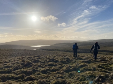
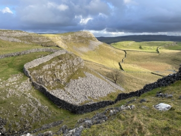
This 1-day Intermediate Navigation Skills course in the Yorkshire Dales will focus on understanding contours and appropriate compass use up on the hills and fells of the Yorkshire Dales.
This course will introduce you to the key hill skills needed to move away from paths and tracks and navigate short legs across hills and open country using contour interpretation and appropriate compass use, from setting the map to ‘quick’ bearings and ‘full’ bearings. We will also look at distance estimation across rough terrain and navigation strategies to enable you to navigate from an ‘attack point’ across open country to a destination such as a Trig Point or to connect parallel paths separated by open country.
This Intermediate Navigation Skills course is suitable for people who already have some navigation skills and wish to develop these skills further to navigate across Open Country. It is ideal for walkers who have attended a 1-day Map Reading course, NNAS Bronze Award or Lowland Leader course and want to move to the next level and learn how to navigate across the hills using compass and contours. It is also a great refresher day for NNAS Silver Award holders and HML trainees.
Or maybe you just want an adventurous day out on the hills….

We will spend the day getting to grips with contours, so we can relate map contours with landform and tie this in with compass work and distances estimation to allow you to navigate across the hills away from paths and tracks for short legs. We’ll also look at navigation strategies, including route simplification, and appropriate compass use.

DO YOU WANT TO..?
- Learn skills for navigating across the hills
- Understand contours and how they relate to the landscape – shape, steepness, direction, height & depth.
- Learn strategies for open country and contour navigation.
- Take compass bearings, and strategies to follow them accurately.
- Distances estimation on the hills – visual, timing and pacing
- Understand the upland environment.
- Explore further, with confidence.
- Stay safe on the hills
- Leave feeling inspired and ready to do more!

COURSE CONTENT
- Move from the valleys up to the open hills.
- Sound decision making and human factors.
- Understand contours, and use prominent landform as a key part of your navigation strategy.
- Compass bearings and strategies including ‘quick’ and ‘full’ bearings, leapfrogging, aiming off and back bearings.
- Distance estimation on the hills (visual, timing and pacing).
- Navigation strategies, including Route Simplification (rough navigation, attack points and then fine navigation).
- Spot hazardous terrain on the map and ground.
- Recognise an error quickly and relocate.
- Understand the upland environment and how this affects route choice, speed of travel and physical discomfort.
- Essential kit for the hills (including safety)
- Legalities – access legislation, personal responsibilities and the Countryside Code.
The topics we focus on will be determined by weather & ground conditions, group needs, visibility, terrain and landscapes, so we may not cover all aspects of this course content in equal detail.
Learning outcome: plan and follow your own walks away from paths and tracks for short legs across open country, with a focus on understanding contours and appropriate compass use.

OUTLINE OF THE COURSE
Pre-course: Unlimited access to our online video tutorials. Watching these videos before the course will allow us more practical time outdoors, and allow you more time to absorb concepts and skills.
- Understanding Contours
- How & When to Use a Compass
- Understanding OS Maps & Symbols
- Navigation Strategies
9:30am: Meet at a village car park in the Yorkshire Dales (with facilities)
9:30am – 4:30pm: Full day’s contour navigation training in the Yorkshire Dales. The walk will usually cover between 6 and 8 miles over the course of the day, with plenty of rest stops and time to practise skills and ask questions.
4:30pm – 5pm: De-brief back at the village.